Advanced GPS for Trucks
- 7.0" high-resolution touchscreen display
- Active Lane Guidance
- Customized truck routing for lower 48 states and Canada
- Lifetime map and traffic updates
- Compatible with Smartphone Link for Android™
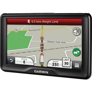
dēzl 760LMT guides with a 7" high-resolution touchscreen — our largest screen yet. Its big, bright display is easy to see across your cab. Extra-loud, enhanced speakers deliver clearly spoken, turn-by-turn directions.
Navigate with Confidencedēzl 760LMT is equipped with voice-activated navigation. Just talk and it responds.
It’s also our only truck navigator with Active Lane Guidance (ALG). ALG prepares you to navigate interchanges with an onscreen animation of the road. As you approach your next turn or exit, dēzl 760LMT displays 2 images. The left is your route and the right is Active Lane Guidance: a live-action model that uses a bright arrow to show which lane you need, with enough time to move into that lane safely.
For added safety, a video input on dēzl 760LMT allows for backup camera compatibility (camera not included). It also integrates Bluetooth® wireless technology with a built-in microphone and speaker for hands-free calling.
Customized Truck Routingdēzl 760LMT is preloaded with detailed maps for the U.S. and Canada that also include truck-related restrictions, such as bridge heights, and related information for most major roads and highways. Just enter your vehicle profile information (customizable by height, weight, length, width and hazardous materials) and find truck-preferred routes suitable for your rig and load. You can also enter multiple stops for more efficient routing. The onboard Trip Planner lets you create multiple-stop routes and plan and save future trips.
Includes Lifetime Map Updates and Trafficdēzl 760LMT features free maps, including updates, for the useful life of your device, so routes are sure to reflect the most up-to-date maps, points of interest and other information.
With the included combination power cable/traffic receiver, your dēzl 760LMT offers free traffic information for the useful life of your device. dēzl 760LMT can help you avoid traffic jams and find the detours you need to keep moving.
Smartphone Link CompatibleSmartphone Link is a free app that connects dēzl 760LMT with an Android™ smartphone. The devices can use the smartphone’s existing data plan to share information, such as where you parked and your current destination.
Smartphone Link also lets you access Garmin Live Services, useful real-time information including weather radar images (subscription required for some services).
Wireless Backup Camera CompatibleEase the stress of moving in reverse by connecting your dēzl 760LMT to our BC 20 wireless backup camera (sold separately). Once connected, dēzl 760LMT conveniently displays the camera footage right on its big screen.
Preloaded with Truck and Trailer ServicesFind points of interest that matter to drivers: from truck stops and weigh stations to lodging and fuel. Truck stop information lists the services offered, such as Wi-Fi, showers and scales. dēzl 760LMT has enhanced exit services to let you know what services are available at upcoming exits along your route.
Make smarter decisions when the unexpected happens. dēzl knows more than 30,000 truck repair and service locations in the continental states and Canada, including those offering after-hours road services.
Note:
- The full product specifications below are from the manufacturer and may contain information related to other package quantities that will not apply to the product that you are reviewing. Please confirm the actual content and/or package quantity from the main product specifications page.
- These specifications may represent the entire product series/model/line to which this product belongs with specific configuration differences between the individual products stated.
- These specifications may have been copied from the same product in other region/country in which case there might be minor differences in region-specific data such as Input Voltage, Terms of Warranty etc.
Physical & Performance
Physical dimensions: 7.4"W x 4.5"H x .9"D (18.7 x 11.4 x 2.3 cm)
Display size, WxH: 6.1"W x 3.4"H (15.4 x 8.6 cm); 7" diag (17.8 cm)
Display resolution, WxH: 800 x 480 pixels
Display type: Color TFT with white backlight
Weight: 12.4 ounces (352 g)
Battery: rechargeable lithium-ion
Battery life: up to 1.5 hours
High-sensitivity receiver: yes
Headphone jack/audio line-out: yes
Maps & Memory
Preloaded street maps: yes
Includes lifetime map updates: yes
nüMaps Guarantee: yes
Built-in memory: internal solid state
Accepts data cards: microSD™ card (not included)
Custom POIs (ability to add additional points of interest): yes
Waypoints/favorites/locations: 1000
Navigation Features
Speaks street names (e.g. "Turn right ON ELM STREET in 500 ft."): yes
Voice-activated navigation (operate device with spoken commands): yes
Traffic compatible (routes around traffic with a receiver and subscription): Yes (receiver and lifetime traffic included)
Lifetime traffic updates (receive free lifetime traffic updates): yes
Lane assist (guides to proper lane for navigation): yes
Junction view (displays junction signs): yes
Route avoidance (avoid highways, tolls etc.): yes
productSpecFeatureHandsFreeCall: yes
Speed limit indicator (displays speed limit for most major roads in the U.S. and Europe): yes
View upcoming points of interest along route: yes
Additional
Additional:
- IFTA fuel logging capability
- HOS violation warnings
- Specialized truck routing supports truck-related restrictions in both the U.S. and Canada (customizable by height, weight, length, width and hazardous materials).
- Truck-specific points of interest
- Exit services (such as rest areas, food, lodging)
- Display elevation grade of current road while driving
- Includes truck specific features such as state border notices, speed limit changes, sunrise/sunset and mile marker info
- External video input for backup cameras